
A Great Flood
The first post in a two-part series on flooding in the Chicagoland area. Part I overviews the history and key drivers of major flooding events in Chicago.

Quick note: I’ve been working on this post for a few weeks now, and put it on pause for a while due to the tragedy in Kerrville, TX. Given how recent it was, I won’t discuss it here. Please do consider donating to Kerr County Flood Relief Fund.
Kerrville and Texas Hill Country is a magical place. It’s also the hometown of my friend Mason Schlechte – one of the best guys I’ve ever known. This post is dedicated to Mason’s memory. Love and miss you buddy.
The Flood Myth
“The world isn't just the way it is. It is how we understand it, no? And in understanding something, we bring something to it, no? Doesn't that make life a story?”
― Yann Martel, Life of Pi
One of my favorite books as a kid was Yann Martel’s Life of Pi. It tells the story of Pi Patel, a teenager stranded at sea with a Bengal tiger named Richard Parker after a shipwreck. What drew me to this book wasn’t the survival story – instead, it was Pi’s musings on faith and religion, which deeply shaped my own views.
Pi was raised Hindu, but also embraced Christianity and Islam, seeing each faith as a different path to the same universal truth. In his words, “Hindus, in their capacity for love, are indeed hairless Christians, just as Muslims, in the way they see God in everything, are bearded Hindus, and Christians, in their devotion to God, are hat-wearing Muslims.”
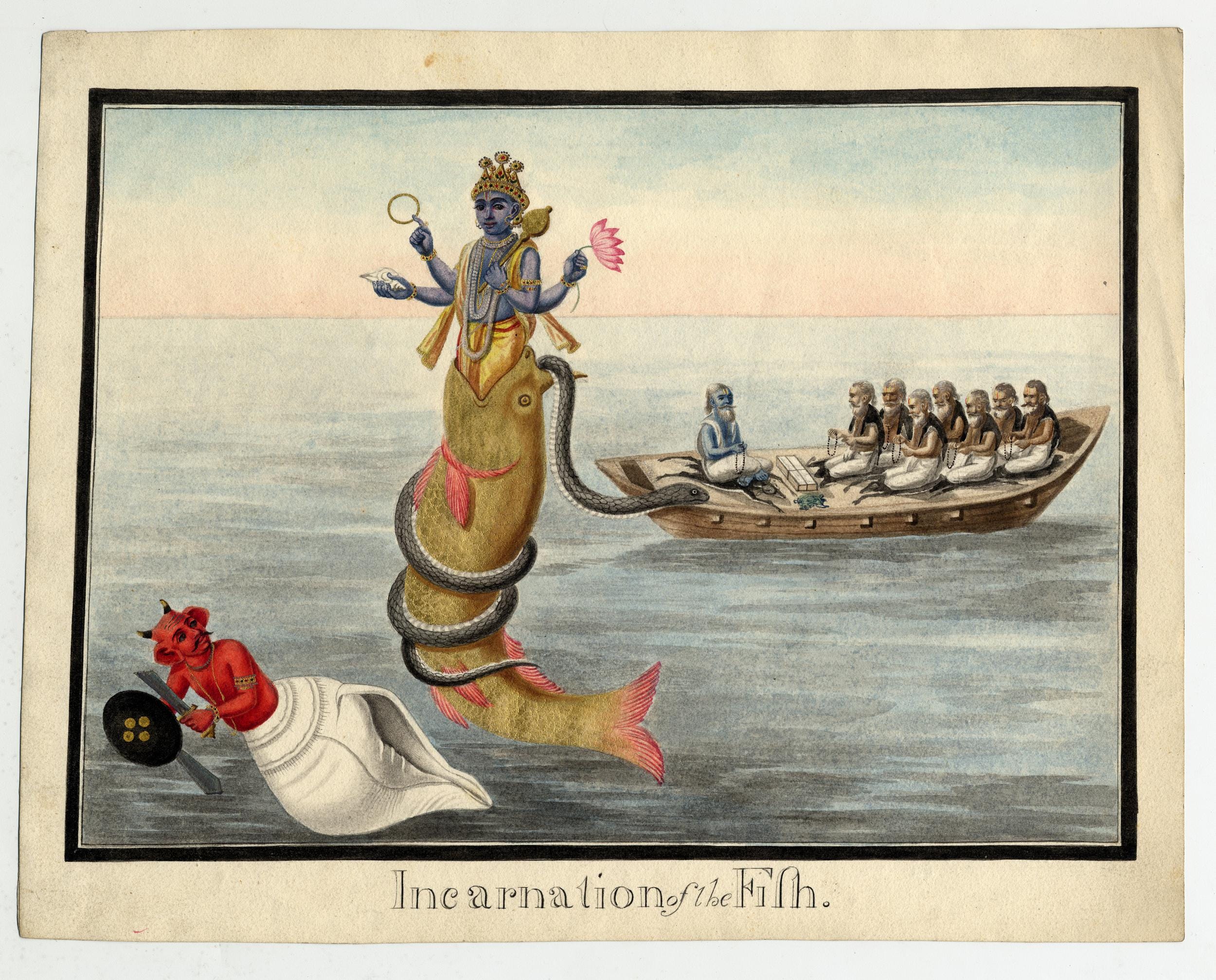
Many readers interpret the novel as an allegory for the biblical story of Noah’s ark, and they’re not wrong. But that interpretation tends to overlook a deeper point that Pi repeatedly gets at: the story of survival at sea isn’t just a Christian allegory – it’s a near-universal one.

A peculiar thing about most major cultures is that they each seem to have their own story of a great flood. They all follow a pretty similar arc: God, angered by humanity’s corruption, sends a devastating flood to cleanse the world and chooses a righteous man to build a boat and start again.
One of the earliest narratives shows up in the Epic of Gilgamesh, written in ancient Mesopotamia around the 19th century BCE. In it, the titular hero meets Utnapishtim, an immortal man tasked by the god Enki to build an ark and preserve all living species after a flood wipes out the rest of humanity.
Sound familiar?
There’s Noah in the Book of Genesis. Deucalion in ancient Greek myth. Manu in the Hindu Matsya Purana. Even in the Great Lakes region, an Anishinaabe legend tells the story of Waynaboozhoo, who survives a great flood by floating on a giant log with the help of birds and four-legged animals.
But how did so many civilizations – separated by thousands of miles and centuries – arrive at such similar stories?
Geologists think they might have an answer.
Earth’s last glacial period ended around 11,000 years ago. As the massive ice sheets retreated, they left behind vast meltwater lakes (like the predecessor to Lake Michigan), often held in place by unstable ice dams. When those dams collapsed, they unleashed catastrophic floods that reshaped entire landscapes. Those who survived the floods likely passed down their stories for millennia.

As humans, we naturally seek meaning in the face of disaster. If you just watched the entirety of the world (to your limited knowledge) get wiped away in a flood, it could be easy to interpret it as divine punishment for your wrongdoings.
But this isn’t just a relic of an ancient time. A fascinating study co-authored by my favorite economist, Joshua Blumenstock, uses mobile phone data to proxy religious adherence in the aftermath of climate shocks (i.e., droughts) in Afghanistan.1 The authors find that people were more likely to strictly observe religious rituals following a climate-related shock – in fact, 24% more likely to do so than after the Taliban seized control of their district.
I won’t offer any answers about religion here, but flooding is one of the most deadly and visceral ways we experience the wrath of nature. And whether it’s divine, natural, or man-made, these events are only likely to grow in frequency and intensity.
So this week, we’re kicking off the first in a two-part series on how flooding impacts Chicagoland, and what the key risk drivers are. In the next post, we’ll explore what steps the city is taking to build flood resilience.
Chicago’s Great Flood(s)
Ask a Chicagoan about our great flood, and they might point to July 2nd, 2023 – the same day as the city’s first NASCAR street race. Over the course of 18 hours, nine inches of rain fell, overwhelming sewers, flooding at least 70,000 basements, and causing nearly $500 million in damages – making it one of the costliest weather events in city history.

So what exactly happened?
Ask a meteorologist, and they’ll tell you a slow-moving low-pressure system triggered repeated torrential rains. Ask an engineer, and they’ll point to our combined sewer-stormwater system, which quickly filled to capacity and overflowed – the Deep Tunnel system and the McCook Reservoir couldn't hold the excess.
What you should take from this is that flooding is as much of a man-made disaster as it is natural, and its solutions are just as complex. In the next couple of sections, we’ll unpack what that means.
Flooding 101
You might remember from this blog’s first post that Lake Michigan and the Chicago River were both born from the same glacial retreat at the end of the last ice age.
Picture a massive ice sheet twice the height of the Sears Tower and stretching across an area of about 5 million square miles. This was the Laurentide Ice Sheet, which once blanketed most of North America. Its last major advance, known as the Wisconsin glaciation, ended roughly 11,000 years ago.
As the ice sheet retreated, it left behind a huge glacial lake (Lake Chicago) and a gently rolling landscape of glacial sediment known as the Valparaiso Moraine. Periodically, the lake would surge over the moraine, unleashing catastrophic floods that likely inspired stories like the Anishinaabe tale of Waynaboozhoo. Over millennia, those floodwaters carved the limestone channel that would become the Chicago River.

So if we want to take the man-or-nature debate over what causes Chicagoland flooding back to its geological origins, nature wins out.
Flooding is indeed a natural part of Chicago’s landscape. The city was built atop a former wetland system that once seasonally overflowed to form the historic Chicago Portage that connected the Great Lakes with the Mississippi River. Its natural topography also contributes to its hydrology: a flat, low-lying plain tucked between Lake Michigan, a branching river system, and gently undulating hills.
But while the roots of flooding may be natural, the severity of modern flood events is often shaped by human decisions, like paving over wetlands with asphalt and concrete, or removing native vegetation that once absorbed excess rainwater and slowed runoff.
We’ll dive into these causes in more detail in a few moments, but first, let’s pause and cover some of the key terminology.
Fluvial Flooding
There are two primary types of river-adjacent flooding in the Chicago area.2 The first is fluvial flooding, which occurs when river levels rise and overflow their banks. This is especially relevant to the Chicago River system, comprised of more than 156 miles of connected waterways.

The land surrounding rivers are called floodplains – demarcated as low-lying areas with at least a 1% chance of flooding in any given year. You’ll often hear this referred to as the “100-year floodplain,” though the name is a bit misleading. It doesn’t mean a flood happens only once every century. Rather, it means there’s a 1-in-100 chance of flooding each year. Over the course of a standard 30-year mortgage, that adds up to a 26% chance of a house being flooded at least once.
In Chicago, river flooding can also be caused by ice jams. During winter, thick layers of ice form on the river’s surface. A sudden warm spell or heavy rainfall can increase runoff, breaking the ice into large chunks that float downstream. These can wedge into tight bends or manmade bottlenecks, forming temporary ice dams. Water backs up behind them, often with little warning, and can lead to serious flooding downstream.

That’s exactly what happened in 1849, when an ice jam caused the first officially recorded natural disaster in Chicago’s early history. The flooding destroyed multiple bridges, damaged or sank dozens of ships, and caused roughly $150,000 in damages – equivalent to more than $6 million today.

Pluvial Flooding
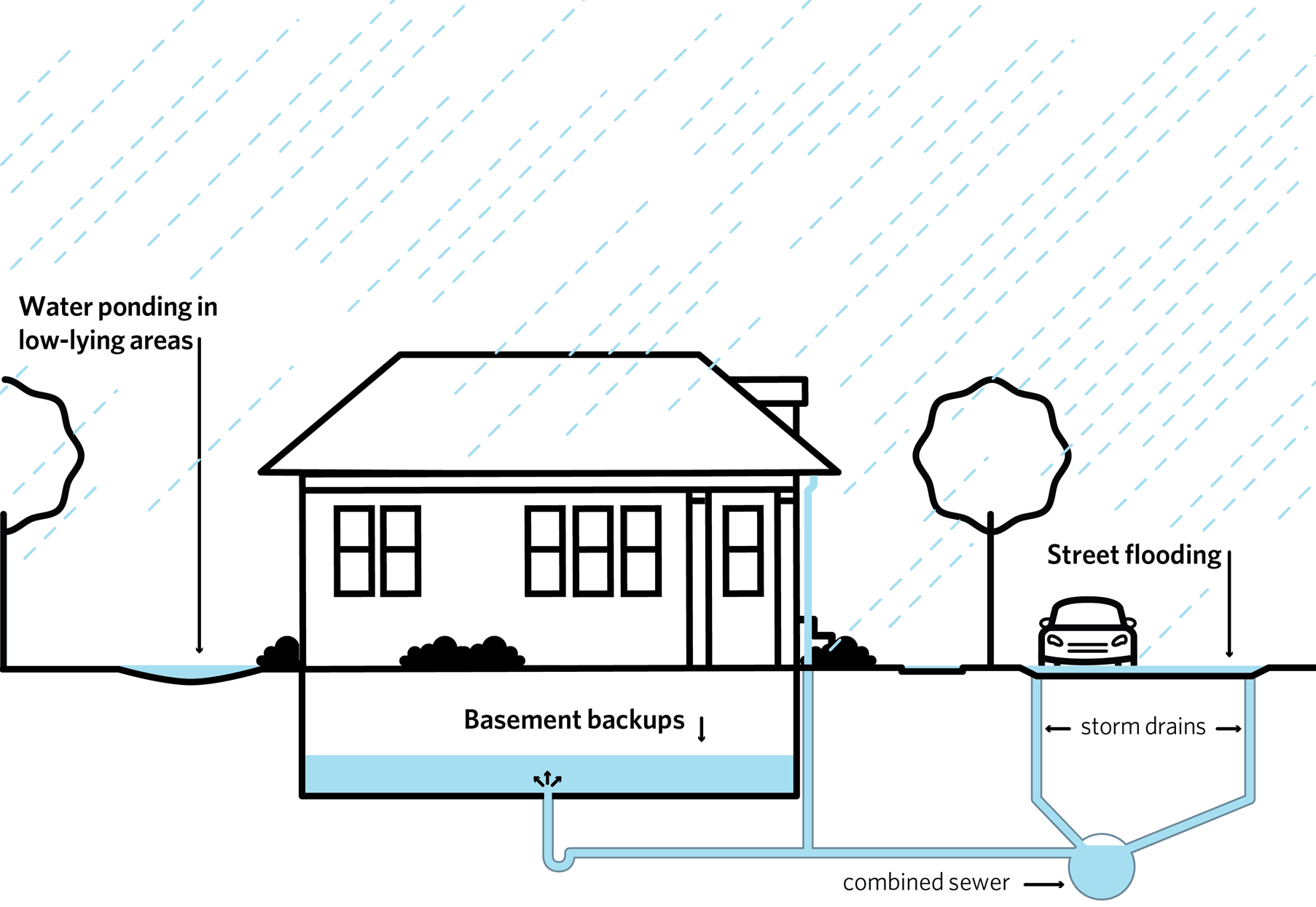
The other – and arguably more problematic – type of flooding is pluvial. This type of flooding doesn’t result from overflowing rivers or lakes. Instead, it results from heavy rainfall that overwhelms the drainage capacity of urban areas.
This type of flooding is heavily influenced by human impacts on the environment, such as expansion of impermeable surfaces (like concrete or asphalt) that prevent rainwater from soaking into the ground, causing it to pool in streets and yards. Another one is the limited capacity of Chicago’s combined sewer and drainage systems. They can lead to the dreaded combined sewer overflows (CSOs), which can lead to a rather nasty mix of sewage and stormwater being emptied into the Chicago River, seeping into basements, ponding in streets and yards, or backing up through drains.
Pluvial flooding is underrepresented in most official flood maps. FEMA’s Flood Insurance Rate Maps focus on coastal and riverine flooding, meaning many urban neighborhoods vulnerable to extreme rainfall are not classified as high-risk. This creates a false sense of security for homeowners, developers, and planners.
This mismatch is a big deal. Between 2007 and 2014, 90 percent of urban flooding damage insurance claims in Chicago were located outside the supposed hundred-year floodplain – demonstrating just how incomplete our data on flood risk is.
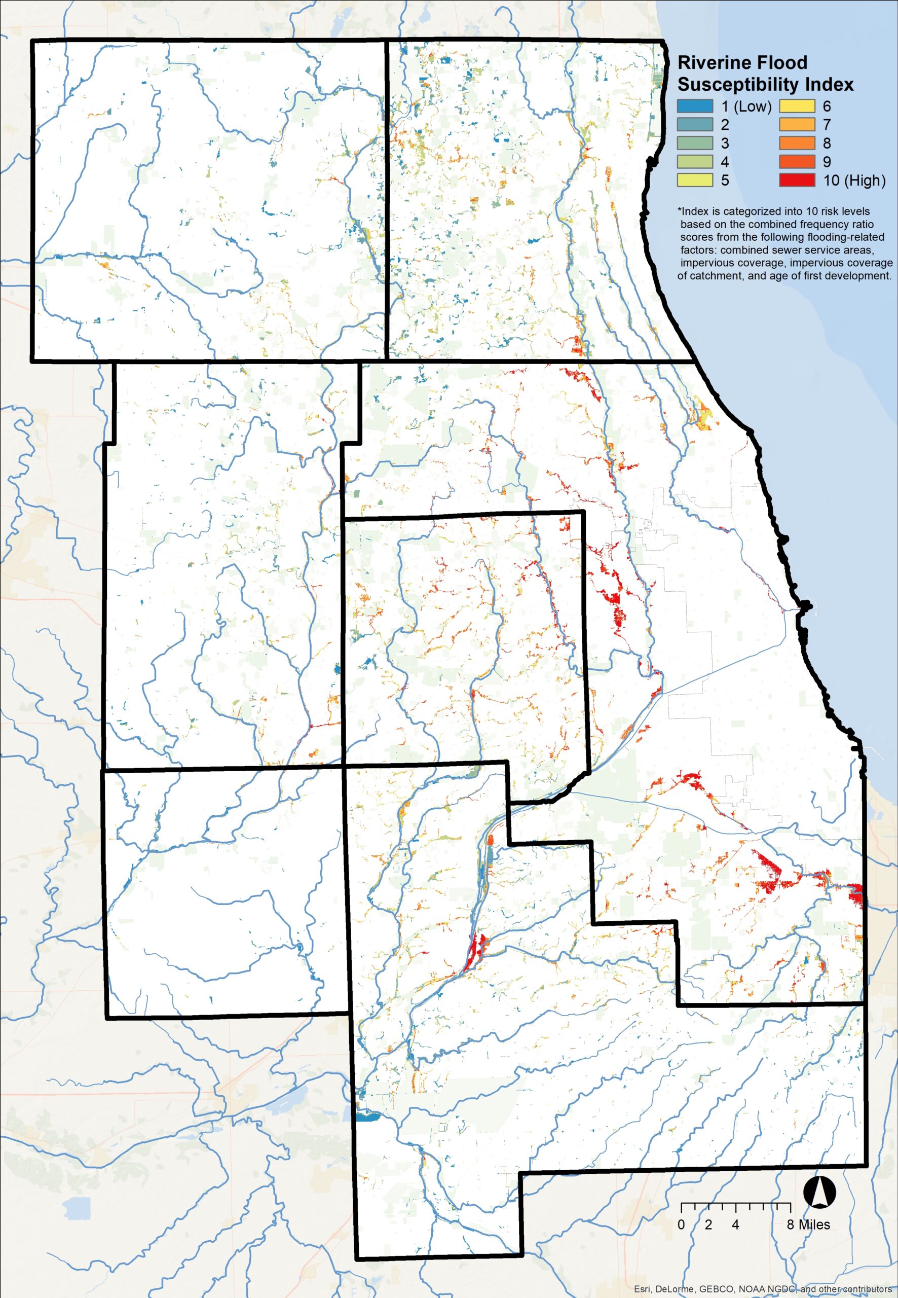
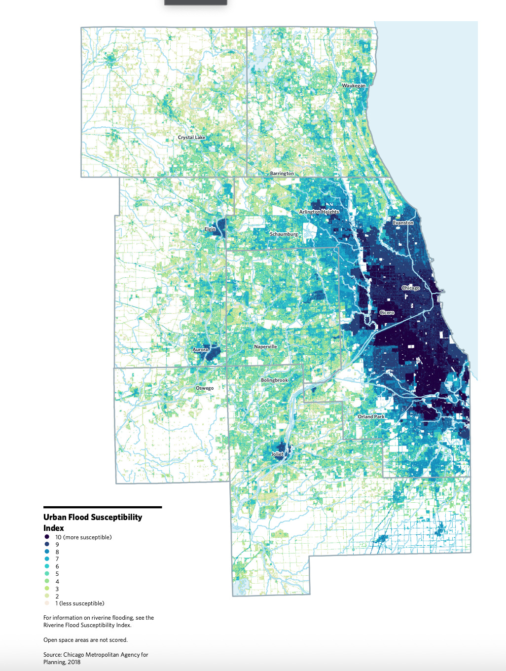
Organizations like the nonprofit First Street are trying to fill this data gap. Their models suggest that over 79,000 properties in Chicago face high flood risk – more than fifty times higher than FEMA’s maps would indicate. The Chicago Metropolitan Agency for Planning (CMAP) also developed their own high-resolution Urban and Riverine Flood Susceptibility Indices which provide a more nuanced and localized view of where flood risks truly lie.
Vulnerability
So why do some areas flood more than others? A few key factors come into play here, each of which are built into CMAP’s indices.
Paving Over Natural Defenses
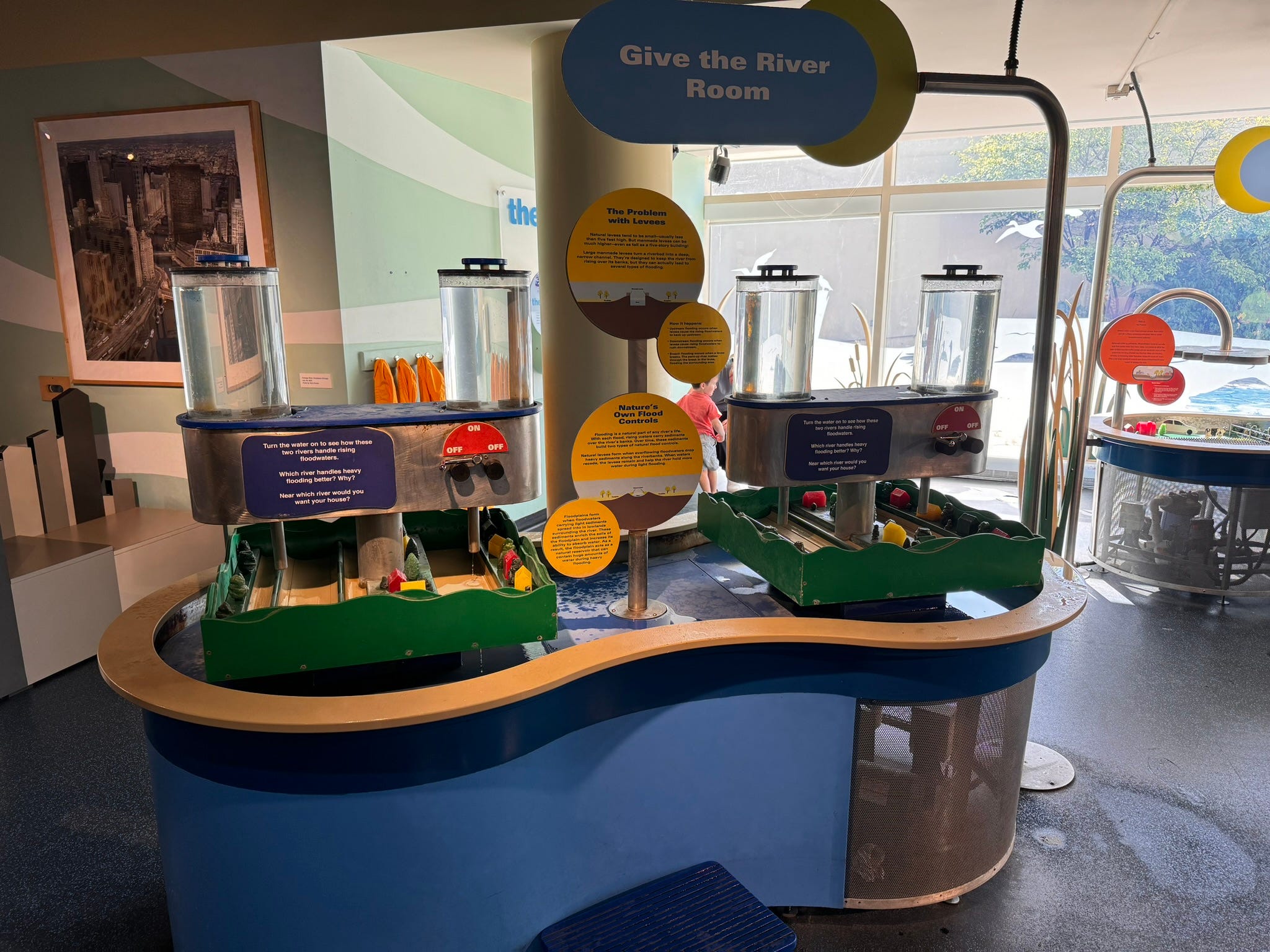
Floodplains aren’t just high-risk zones – they’re natural flood management infrastructure. Wetlands and prairies once acted as natural storm buffers, soaking up rainfall and slowly releasing it into groundwater storage. This is because the long, complex root networks of native wetland plants allow it to penetrate deep into the dirt, creating thick layers of absorbent topsoil that can storage significant amounts of rainwater.
But as Chicago urbanized, much of this landscape was paved over with roads, parking lots, and sidewalks made of asphalt and concrete. These impervious surfaces prevent water from soaking into the ground, causing it to flow rapidly across the surface and overwhelm drainage systems. The result? More pooling, sewer backups, and flash flooding.
As we’ll explore in Part II, restoring urban green space isn’t just about aesthetics – it’s a frontline defense against flooding. The lack of permeable land plays a major role in why 87% of flood damage insurance claims paid out between 2007 and 2016 were concentrated in Chicago’s southern and western neighborhoods, predominantly communities of color.
Inadequate Stormwater Infrastructure
Like many cities around the world, most sewers in Chicago were initially built in the mid-19th century. Because the system predated the invention of modern wastewater treatment techniques, our sewers are a combined system – meaning that they were designed convey both sewage and stormwater and dump them into the Chicago River. In the mid-20th century, the city added intercepting sewers to divert combined flows to newly constructed treatment plants, but these systems were only built to handle limited capacity.

During intense storms, sewer mains fill quickly and might back up through private drains. This is especially problematic for homes where gutter downspouts are connected directly to those drains – if the system is overwhelmed, the water has nowhere to go but into your basement.
The Department of Water Management designs city sewers to handle a “five-year storm”– a rainfall event with a 20% chance of occurring in any given year. In Northeast Illinois, that equates to roughly four inches of rain in 24 hours, according to the Illinois State Water Survey. As climate change drives more frequent and intense storms, this standard is increasingly insufficient.3
To address this, the city launched the $4 billion Tunnel and Reservoir Plan (TARP) – also known as the Deep Tunnel. This vast underground network is designed to store up to 17.5 billion gallons of wastewater during major storms, holding it until it can be treated. In Part II, we’ll discuss how this infrastructure shapes Chicago’s resilience to extreme precipitation events.
Topography
Flood risk isn’t just about proximity to water. In flat cities like Chicago, stormwater doesn’t always have a natural path to drain away – so it pools. That’s where topography comes into play.
CMAP uses a tool called the Topographic Wetness Index (TWI) to model where water is most likely to accumulate. It factors in slope, drainage area, and landform shape using GIS data to identify low-lying, poorly drained areas with a high risk of surface flooding.
Elevation also matters. The Base Flood Elevation (BFE) estimates how high floodwaters are expected to rise during a 100-year flood. CMAP found that many properties repeatedly affected by floods—even outside the mapped floodplain—have basements located below the BFE. Properties with an elevation within six feet of the nearest BFE are flagged as particularly vulnerable.
Aging Buildings
Finally, it’s worth remembering that flood-resilient construction is a relatively recent development. National floodplain regulations weren’t enacted until 1968, and stormwater ordinances didn’t emerge until the 1970s. Much of Chicago’s housing stock predates these protections.
Older buildings are more likely to have aging pipes, porous foundations, and basement levels built below the water table – all of which make them more susceptible to flooding, regardless of whether they’re in a mapped flood zone.
Concluding Thoughts
Urban flooding is a complex, multifaceted challenge, driven by both natural forces and human decisions. Understanding what causes it is just the first step. The more difficult, and critical, task is how we respond.
So how do we design cities that can mitigate and adapt to the increasingly intense and unpredictable flooding events that are likely to define the 21st century? We’ll dive in that and more in the next post. Part II will dive a bit deeper into what climate models say about the future of extreme precipitation events, the infrastructure and nature-based solutions already being implemented across Chicago, and emerging theories in urban design that could help us build safer, more resilient cities for the decades ahead.
The authors use a very cool identification strategy here. Using data on 22 billion calls placed by 10 million Afghanis over an eight-year period, they observe that call volumes drop by approximately 25 percent during the evening Maghrib prayer window. This creates an interesting proxy for religious adherence.

For conciseness, I’m going to skip over a third category: coastal flooding. This type of event happens when lakeshore neighborhoods are inundated due to significant changes in lake levels. This is particularly prevalent in South-side neighborhoods like South Shore which lack natural or artificial barriers to prevent erosion from severe wave/tidal activity. I recommend this article if you’re interested in learning more.
Lincoln & Ford 2024 provides an excellent overview of the history of extreme precipitation events in the Chicago area (defined as 7.5 inches in a 24-hour period, or a 100-year flood).